. March 2011 ~ Beautiful Pakistan
  • RSS
  • Facebook
  • Youtube
  • We have moved to new website As of today, all new content will only be posted on the new site
  • Lakes In Pakistan

    We have been moved to our new website. As of today, all new content will only be posted on the new site which can be accessed by going to: http://truthaboutpakistan.com/

  • Lakes In Pakistan

    We have been moved to our new website. As of today, all new content will only be posted on the new site which can be accessed by going to: http://truthaboutpakistan.com/

Sunday, March 13, 2011

Nanga Parbat Pakistan

Posted by khubaib abbasi On 1:59 PM

       Nanga Parbat is the ninth highest mountain on Earth and second highest mountain in Pakistan and among the eight-thousanders, Nanga Parbat and second highest mountain in Pakistan  it is the largest single mountain. Nanga Parbat translates to "Naked Mountain" in English; parbat deriving from the Sanskrit word parvata meaning "mountain, rock", and nanga an Urdu word meaning "naked" Known as the "Killer Mountain", Nanga Parbat was one of the deadliest of the eight-thousanders for climbers in the first half of the twentieth century; since that time it has been less so, though still an extremely serious climb. It is also an immense, dramatic peak that rises far above its surrounding terrain. 
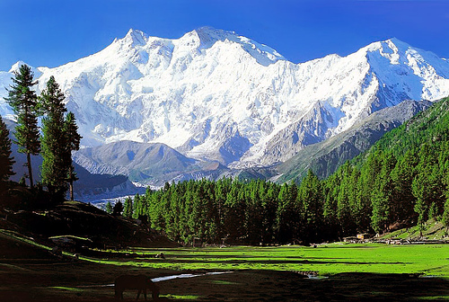
               Nanga Parbat is present inHimalayan Range. Nanga Parbat has a height of 8126 meters/26,660 ft. It has three vast faces. The Rakhiot (Ra Kot) face is dominated by the north and south silver crags and silver plateau; the Diamir face is rocky in the beginning. It converts itself into ice fields around Nanga Parbat peak. The Rupal face is the highest precipice in the world. Reinhold Messner, a living legend in mountaineering from Italy, says that "every one who has ever stood at the foot of this face (4500 meters) up above the 'Tap Alpe', studied it or flown over it, could not help but have been amazed by its sheer size; it has become known as the highest rock and ice wall in the world!".
          Nanga Parbat has always been associated with tragedies and tribulations until it was climbed in 1953. A lot of mountaineers have perished on Nanga Parbat since 1895. Even in recent years it has claimed a heavy toll of human lives of mountaineers, in search of adventure and thrill. Its victims, have included those in pursuit of new and absolutely un-climbed routes leading to its summit.
           The Nanga Parbat peak was discovered in the nineteenth century by Europeans. The Schlagintweit brothers, who hailed from Munich (Germany) came in 1854 to Himalayas and drew a panoramic view which is the first known picture of Nanga Parbat. In 1857 one of them was murdered in Kashgar. The curse of Nanga Parbat had begun.


Sunday, March 06, 2011

Bala Hisar Fort Pakistan

Posted by khubaib abbasi On 4:02 PM

Bala Hisar Fort is one of the most historic places of Peshawar. The word Bala Hisar is from Persian, meaning, “elevated or high fort”. According to Dr. Hussain Khan, the name was given by the Afghan King Timur Shah Durrani (1773–1793). The Sikhs who conquered Peshawar in the early 19th century named it Samir Garh in 1834 but the name did not become popular.. Located just to the North West of the city and the North of the Lady Reading Hospital, Bala Hisar covers a part of the ancient Shalamar Garden of Peshawar. This many centuries old Fort of Peshawar, along with many gardens around the city, were  destroyed by the Sikhs, but a  Sikh sardar, Kurruck Singh,  is said to have rebuilt the fort of Bala Hisar of unburnt bricks and named its Suumunger.These are the references to the strengthening of the fort of Peshawar  by King Babar, which confirms the existance of the fort before Mughals.  The present burnt brick structure  of the fort belongs to the British era. This historic fort is now occupied by the Frontier Constabulary. 

The fort stands on a high mound in the northwestern corner of Peshawar City. Not long ago, the fort used to be conspicuously away from the old city of Peshawar, but now the construction of new buildings has covered space between the old city and the fort. However, the fort's position on a high mound gives a commanding and panoramic view of Peshawar and the entire Peshawar valley.
In the early nineteenth century, Peshawar was the summer capital of the Kingdom of Kabul and the Balahisar the residence of Afghan kings. The Sikhs fought and defeated the Kabul Barakzais in the Battle of Nowshera in early 1823. On conclusion of this battle, fought on the right bank river Indus, the Sikhs chased the retreating Afghans past Peshawar through the Khyber Pass.


Quetta Pakistan

Posted by khubaib abbasi On 3:33 PM

Quetta is the largest city and the provincial capital of the Balochistan Province of Pakistan. Quetta is known as the "Fruit Garden of Pakistan", due to the diversity of its plant and animal wildlife. Situated at an average elevation of 1,654 metres (5,429 ft) above sea level. Quetta sits near the Durand Line border with Afghanistan and is an important trade and communications centre between the two countries as well as an important military location occupying a vital strategic position for the Pakistani Armed Forces. The city lies on the Bolan Pass route which was once the only gateway to and from South Asia. The city was the closest city to the 1935 and the 2008 earthquakes both of which resulted in a great deal of damage to the city and significant loss of life. Quetta has a desert climate (Köppen BWk) with a significant variation between summer and winter temperatures. Summer starts in late May and goes on until early September with average temperatures ranging from 24-26 °C (75-78 °F).The highest temperature in Quetta is 42 °C (108 °F) which was recorded on 10th July, 1998.
Quetta is a tourist attraction for foreigners to whom it is advertised as a "thrilling location, full of adventure and enjoyment". Among the attractions are the bazaars located on the Shahrah-e-Iqbal (Kandahari Bazaar) and Shahrah-e-Liaquat (Liaquat Bazaar and Suraj Gang Bazaar. In the bazaars are colourful handicrafts, particularly Balochi mirror work and Pashtun embroidery both of which are admired world-wide. The Pashtun workers are expert in making fine Afghan rugs, with their pleasing and intricate designs, fur coats, embroidered jackets, waist-coats, sandals and other traditional Pashtun items. Also in the city is the army administered Askari Park, constructed in the 1990s and located on Airport Road, which has a children's playground equipped with modern rides, toys and entertainment.

Hanna Lake, which nestles in the hills ten kilometres (six miles) east of the city, is a startling turquoise pool which contrasts markedly with its bare brown surroundings. An attraction for holidaymakers, with facilities for boat hire and a lakeside restaurant, it is crowded by hikers and campers in holiday periods. At one end there is an irrigation dam while on the eastern shore line there is Hayat Durrani Water Sports Academy, the only water sports training center in Balochistan Province. The Hana Lake Development Authority, the Hayat Durrani Water Sports Academy and Merck Marker (Pvt.) Ltd. have planted a range of trees in the Hanna Lake Mountains both for beautification and the protection of the environment .


Copyright © 2010 Beautiful Pakistan. Powered by Blogger.